All three of the BBC News website’s March 21st and March 22nd reports concerning the US president’s announcement of the intention to recognise Israeli sovereignty over the Golan Heights included links to the BBC’s profile of that area which was last updated on March 14th.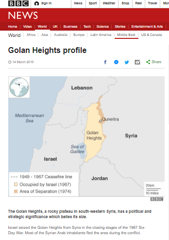
In that profile BBC audiences are told that:
“The area [Golan Heights] is also a key source of water for an arid region. Rainwater from the Golan’s catchment feeds into the Jordan River. The area provides a third of Israel’s water supply.”
While that may have been the case in the past, does the Golan Heights really currently provide “a third of Israel’s water supply”?
A document produced by the Knesset Research and Information Center last year shows that three main natural sources – one of which is the Kinneret (Sea of Galilee) basin – currently together provide just 40% of Israel’s water.
“The Israeli water sector has natural and artificial sources of water. The main natural sources are the Kinneret Basin, which includes aquifers and rivers that flow into the Sea of Galilee, the Coastal Aquifer, and the Mountain Aquifer. Natural fresh water makes up some 40% of water consumption. In addition to the sources of natural water, two sources of artificial water play a vital role in the water sector: desalinated water (mostly seawater), which in 2016 provided 25% of water consumption, and reclaimed wastewater, used mostly for agriculture, which in 2016 provided 25% of the water consumed across all sectors.”
Moreover, rainfall on the Golan is just one of several sources of water supply to the Sea of Galilee and, as the Knesset report goes on to say:
“For years, Israel has faced a water crisis, which has manifested itself in low precipitation and dwindling natural resources (groundwater and sources of surface water, primarily the Sea of Galilee). The drought in Israel’s north, an area that usually receives greater precipitation, is particularly severe.”
“…the volume of water flowing into the Sea of Galilee in the past four years is the lowest ever on record: in August 2017, water flow to the Sea of Galilee reached a record low—that month, the Sea of Galilee lost 26 MCM of water (the previous record was set in August 2014). As a result, the water level in the Sea of Galilee is expected to drop and may break the record low set in 2001, despite the fact that almost no water has been pumped from the Sea of Galilee in recent years.” [emphasis added]
With the Sea of Galilee being only one of the three main natural sources which together currently provide just 40% of Israel’s water supply and the Golan Heights being only one of several severely reduced sources of water to the lake, the BBC’s claim that a third of Israel’s water supply comes from the Golan Heights is clearly inaccurate and misleading.
Readers of this profile also find the following:
“Syria wants to secure the return of the Golan Heights as part of any peace deal. In late 2003, Syrian President Bashar al-Assad said he was ready to revive peace talks with Israel.
In Israel, the principle of returning the territory in return for peace is already established. During US-brokered peace talks in 1999-2000, then Israeli prime minister Ehud Barak had offered to return most of the Golan to Syria.
But the main sticking point during the 1999 talks is also likely to bedevil any future discussions. Syria wants a full Israeli withdrawal to the pre-1967 border. This would give Damascus control of the eastern shore of the Sea of Galilee – Israel’s main source of fresh water.
Israel wishes to retain control of Galilee [sic] and says the border is located a few hundred metres to the east of the shore.” [emphasis added]
There is of course no such thing as a “pre-1967 border”. There is however a 1923 border set out by the then mandatory powers Britain and France.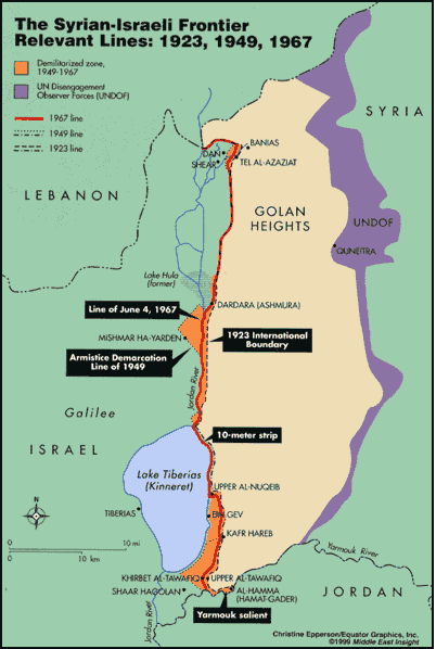
“The territorial aspects of the Syrian-Israeli dispute date to 1920–23, when Great Britain and France devised a boundary between Syria (then including “Greater Lebanon”) and Palestine, two entities that would fall under League of Nations mandates. Often referred to as the “1923 international boundary,” the line was drawn to keep the upper course of the Jordan River (between Lake Hula and the Sea of Galilee) and the Sea of Galilee itself entirely within Palestine and to give Palestine a few kilometers of frontage on the Yarmouk River. Between Lake Hula and the Sea of Galilee, the boundary ran between fifty and four-hundred meters east of the Jordan River, just below the Golan Heights. Along the northeastern shore of the Sea of Galilee, it ran parallel to the shore and ten meters from the water’s edge. Sovereignty over these water resources was vested in Palestine.” [emphasis added]
There is also a 1949 Armistice Agreement Line, which was specifically defined as not being a border. Article V of the agreement states:
“1. It is emphasized that the following arrangements for the Armistice Demarcation Line between the Israeli and Syrian armed forces and for the Demilitarized Zone are not to be interpreted as having any relation whatsoever to ultimate territorial arrangements affecting the two Parties to this Agreement.
2. In pursuance of the spirit of the Security Council resolution of 16 November 1948, the Armistice Demarcation Line and the demilitarized Zone have been defined with a view toward separating the armed forces of the two Parties in such manner as to minimize the possibility of friction and incident, while providing for the gradual restoration of normal civilian life in the area of the Demilitarized Zone, without prejudice to the ultimate settlement.” [emphasis added]
As documented by Frederic C. Hof:
“During the 1948 Arab-Israeli War, Syrian troops penetrated Palestine-Israel in several areas. When an armistice was signed in July 1949, Syrian forces still held blocs of territory west of the 1923 international boundary. The parties agreed to a compromise: Syrian forces would withdraw from the farthest extent of their advance (the truce line—later the Armistice Demarcation Line [ADL]) to the 1923 international boundary, and Israel would refrain from introducing military forces into areas vacated by Syria. Thus was created a demilitarized zone consisting of three, non-contiguous blocs of land in what had been mandate Palestine totaling 66.5 square kilometers. In some places the ADL corresponded to the 1923 international boundary, and in others it penetrated into the former Palestine mandate. The demilitarized zone was everything between the ADL and the 1923 international boundary. Syria — quite inexplicably — agreed that the ADL along the northeastern shore of the Sea of Galilee would correspond to the 1923 international boundary (i.e., the 10-meter strip), even though its soldiers and civilians enjoyed access to the sea’s waters before, during, and after the 1948 fighting. Therefore, any time a Syrian national—military or civilian— crossed the invisible line to swim or fish an armistice violation occurred. Israel claimed sovereignty over the entire 66.5 square kilometer zone. Syria did not, reserving its claims for a future peace conference.” [emphasis added]
There is also what is termed the Line of June 4, 1967 (link includes map). That line is also not a border: it represents the positions – despite the Armistice Agreement – held by Israel and Syria on the eve of the Six Day War.
“Neither side lived up to its [Armistice Agreement] obligations. Syria retained pieces of the demilitarized zone, including the Palestinian Arab town of El Hamma on the Yarmouk River, and treated the 10-meter line paralleling the northeastern shoreline of the Sea of Galilee as if it did not exist. […] Secret talks in 1952–53 to partition the demilitarized zone failed. Between 1954 and 1967 there was a “game of inches” for control of the zone, always fought to the advantage of Israel. On the eve of war in June 1967, Syria still controlled the 10-meter strip and some 18 of the zone’s 66.5 square kilometers, including El Hamma (along with a small salient to its west along the Yarmouk River), the east bank of the Jordan River between Lake Hula and the Sea of Galilee, some high ground overlooking the Sea of Galilee, and a small patch of land overlooking the Hula Valley.” [emphasis added]
Hof goes on:
“As a result of American shuttle diplomacy, Syria came to believe, by July 1994, that Israel would seriously contemplate full withdrawal “to the line of June 4, 1967” in return for a peace treaty satisfactorily addressing Israel’s core concerns. Syria demanded that all land wrested by Israel from Syrian control in June 1967—18 square kilometers of demilitarized zone in the Jordan Valley and the 10-meter strip along the northeastern shore of the Sea of Galilee and the Golan Heights—be returned to Syria in its entirety. […] Syria wanted a line that had, for the most part, not been demarcated: a line that, in several key areas, corresponded neither to the 1923 international boundary nor to the 1949 ADL. Syria wanted the eve of war (1967) status quo restored and a boundary drawn reflecting, in effect, a snapshot of who was where on June 4, 1967.”
In other words, the BBC falsely claims the existence of a “pre-1967 border” and its assertion that the existence of a border to the east of the shore of the Sea of Galilee is something that only “Israel says” exists is untrue.
The claim that a return to a “pre-1967 border” would “give Damascus control of the eastern shore of the Sea of Galilee” is inaccurate, seeing as the only border in existence prior to 1967 was the one agreed upon in 1923 by France and Britain which left access to the lake within the borders of Mandate Palestine.
Related Articles:
Partial portrayals of international law in three BBC reports